Pilot Information
 
Services
Public Information
 

City of Bowling Green Ohio


Runway Information


Runway 10 / 28

Dimensions: 4199’ x 75’

Surface: Asphalt, no surface treatment, in good condition

Runway Edge Lights: Medium


#

Elev/Hdg

Traffic Pattern

Lights

Comments


10


671.4 ft MSL

96° Mag

91° True


http://www.aopa.org/airports/resources/images/airport-icon-lp.gif

Visual glide slope; 4-Light / Left – Side PAPI; Runway end identifier; REIL is present


None


28


671.3 ft MSL

276° Mag

271° True


http://www.aopa.org/airports/resources/images/airport-icon-rp.gif

Visual glide slope; 4-Light / Left – Side PAPI; Runway end identifier; REIL is present


None


Runway 18 / 36

Dimensions: 2628’ x 50’

Surface: Asphalt, no surface treatment, in good condition

Runway Edge Lights: Medium


18


671.4 ft MSL

184° Mag

179° True


http://www.aopa.org/airports/resources/images/airport-icon-lp.gif

Visual glide slope; 4-Light / Left-side PAPI; Runway end identifier; REIL is present


None


36


671.3ft MSL

4° Mag

359° True


http://www.aopa.org/airports/resources/images/airport-icon-rp.gif


No Lighting


57’ Displaced Threshold. Road, 260ft Left of center, 16ft high, 268ft from end, 4:1 clearance slope


Additional Remarks

  • 160ft AGL Stadium Lights .6NM SE of Airport
  • Flock of Geese on & Invof Airport During Fall & Winter
  • Runway 28 is the Calm Wind Runway when wind is 5 Knots or Less
  • Intensive Flight Training 


Fuel Prices

Facebook Twitter

 
Home | About | Arrival Information | Contact
Copyright 2010 Wood County Regional Airport

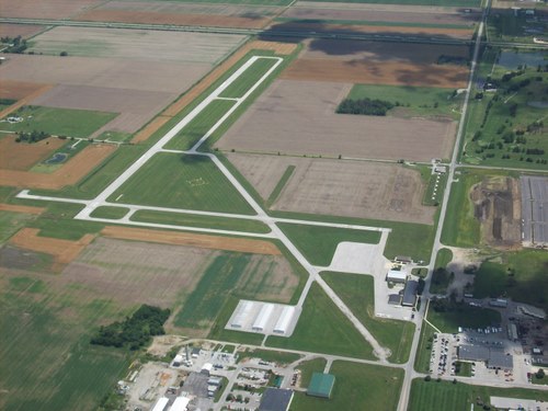
(The information contained on this page may not be current. Please consult the
Airport Facilities Directory and NOTAMS for the most current data on 1G0.)

Not For Navigational Use